Indies Gallery
Antique Maps & Prints of Indonesia
Search
MY ACCOUNT
Sign in
Login
Create Account
Forgot Password
0
Menu
Sign in
Login
Create Account
Forgot Password
Antique Maps Indonesia
New Additions
About Us
Contact Us
Gifts Under $350
Sell To Us
Catalogues
Newsletters
Search
Asia Maps (71)
- South East Asia Maps (103)
- - India & Sri Lanka Maps (25)
- - Philippine Maps (16)
- - Thailand Maps (4)
- Indonesia Maps (131)
- - Batavia & Jakarta Maps (21)
- - Java Maps (38)
- - Sumatra Maps (35)
- - Bali & Lombok Maps (12)
- - Borneo & Kalimantan Maps (18)
- - Moluccas & Spice Islands Maps (34)
- - Papua Maps (11)
- - Sulawesi & Celebes Maps (2)
- - Flores & Komodo Maps (5)
- Singapore & Malaysia Maps (57)
- China Maps (44)
- Japan Maps (14)
- Korea Maps (20)
World Maps (15)
Australia & Oceania Maps (16)
- Australia Maps (57)
- New Zealand Maps (6)
- Oceania Maps (6)
- South Pacific Islands (4)
- Captain Cooks Voyages (3)
Americas Maps (10)
- North America Maps (6)
- Central America & Caribbean (6)
- South America Maps (7)
Europe Maps (13)
Africa Maps (10)
Pre-1750 Maps (75)
Sea Charts & Maritime Maps (22)
Arabia Maps (7)
Indonesia Prints (401)
- Inhabitants Prints (243)
- Naval & Maritime Prints (79)
- Architectural Prints (133)
- Temples in Indonesia Prints (100)
- The Old Batavia Prints (79)
- Bogor - Buitenzorg (30)
- Java Prints (340)
- Bali Prints (36)
- Sumatra Prints (34)
- Borneo Prints (60)
- Moluccas & Spice Islands Prints (111)
- Celebes/Sulawesi (10)
- Wayang Prints (41)
- Papua Prints (55)
- Dance & Music (65)
- Yogyakarta Prints (77)
- Batik Prints (86)
- Costumes & Attire Prints (128)
Malaysia & Malacca Prints (20)
Singapore Prints (42)
Views & Landscapes Prints (126)
Flora & Fauna Prints (477)
- Botanical (324)
- - Plants & Trees Prints (181)
- - Leaves Prints (209)
- - Fruits Prints (61)
- - Flowers Prints (146)
- - Spices Prints (40)
- Birds (199)
- Insects (18)
- Sea Life (104)
- Mammal Prints (47)
Mammals Prints (15)
Australia Prints (45)
- Captain Cooks Voyages Prints (51)
Ethnology Prints (110)
Exploration Prints (124)
Tribal Art Prints (57)
Oceania Prints (61)
China Prints (14)
Indian Prints (35)
Philippines Prints (9)
New Zealand Prints (3)
Antique Books (34)
Vintage Posters (17)
Singapore Photographs (63)
Indonesia Photographs (17)
- People Photographs (10)
- Batavia Photographs (6)
- Surabaya Photographs (1)
- Java Photographs (8)
- Sumatra Photographs (4)
Malaysia Photographs (2)
Architecture Photographs (32)
Streets Photographs (5)
Views & Landscapes Photographs (21)
Australia and New Zealand (5)
Tribal & Ethnographic Art (2)
Special Collection (80)
All Categories
>
Antique Maps
(347)
Antique Prints
(1428)
Antique Books
(34)
Vintage Posters
(17)
Antique Photographs
(182)
Tribal & Ethnographic Art
(2)
Special Collection
(80)
New Additions
Gifts Under $350
Catalogues
Newsletters
About Us
Contact Us
Sell To Us
Category : Indonesia Maps
Sort By :
Lowest Price
Highest Price
Recently Added
Sold
Unsold
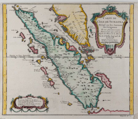
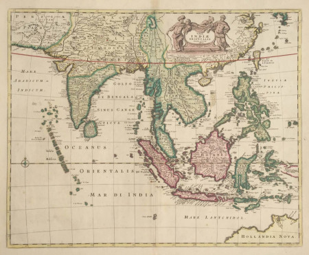
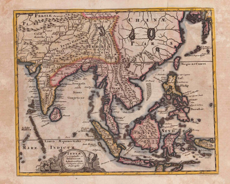
Sumatra, Malaysia and Singapore
Jacques Nicolas Bellin
Antique Maps
/
Indonesia Maps
/
Singapore & Malaysia Maps
/
Sumatra Maps
Year:
ca.1750
Size:
32 by 21 cm.
Condition:
G+ / Study image carefully
SKU:
M.0217
Price:
USD 380
USD 380
Add to Basket
View Detail
Add to Favourites
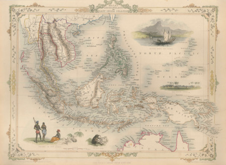
The Malay Archipelago - English Map
John Tallis
Antique Maps
/
South East Asia Maps
/
Indonesia Maps
Year:
1851
Size:
36 by 27 cm.
Condition:
VG+
SKU:
M.6018
Price:
USD 580
USD 580
Add to Basket
View Detail
Add to Favourites
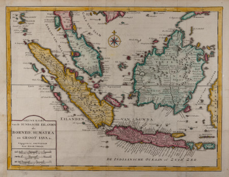
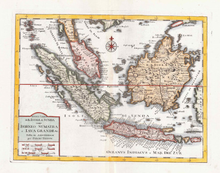
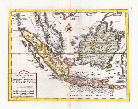
Indonesian Islands, Java, Sumatra and Borneo
Isaak Tirion
Antique Maps
/
Indonesia Maps
/
Java Maps
/
Sumatra Maps
/
Borneo & Kalimantan Maps
Year:
ca. 1730
Size:
40 by 32 cm.
Condition:
G+ / Study images carefully
SKU:
M.6013
Price:
USD 520
USD 520
Add to Basket
View Detail
Add to Favourites
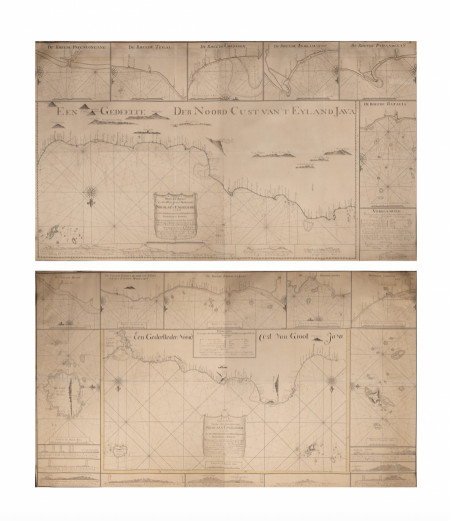
Java’s North Coast - Large Manuscript Charts
Nicolas Engelhard
Antique Maps
/
Indonesia Maps
/
Batavia & Jakarta Maps
/
Java Maps
/
Special Collection
/
Sea Charts & Maritime Maps
Year:
1806 - 07
Size:
ca. 165 by 95 cm. (each chart)
Condition:
G+ / Study images carefully
SKU:
M.0437
Price:
USD 88,000
USD 88,000
Add to Basket
View Detail
Add to Favourites
Southeast Asia - Large English “Test State” Map
Hermann Moll
Antique Maps
/
Asia Maps
/
South East Asia Maps
/
Indonesia Maps
/
Singapore & Malaysia Maps
/
China Maps
/
Special Collection
/
Pre-1750 Maps
Year:
ca.1730
Size:
101 by 62 cm.
Condition:
G+ / Study images carefully
SKU:
M.6010
Price:
Price on Request
Price on Request
Request Price
View Detail
Add to Favourites
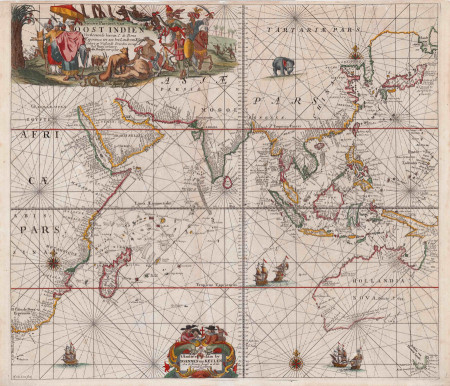
Indian Ocean Sea Chart, Dutch Golden Age Map
Van Keulen
Antique Maps
/
Asia Maps
/
South East Asia Maps
/
Indonesia Maps
/
Singapore & Malaysia Maps
/
Korea Maps
/
Australia Maps
/
Special Collection
/
Africa Maps
/
Pre-1750 Maps
/
Sea Charts & Maritime Maps
Year:
1680
Size:
51 by 58 cm.
Condition:
VG
SKU:
M.6006
Price:
USD 16,800
USD 16,800
Add to Basket
View Detail
Add to Favourites
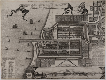
City Plan of Batavia (Jakarta)
Pieter van der Aa
Antique Maps
/
Indonesia Maps
/
Batavia & Jakarta Maps
/
Java Maps
Year:
ca.1725
Size:
35 by 26.5 cm.
Condition:
G- / Study images carefully
SKU:
M.6004
Price:
USD 680
USD 680
Add to Basket
View Detail
Add to Favourites
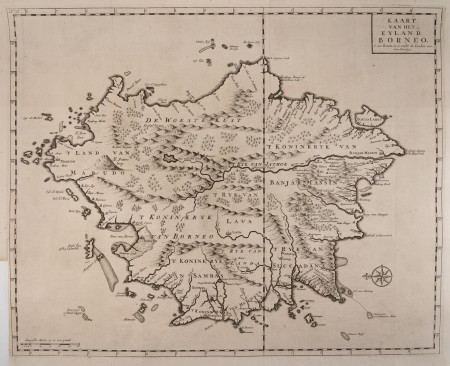
Borneo Island - Large Map
Francois Valentyn
Antique Maps
/
Indonesia Maps
/
Borneo & Kalimantan Maps
Year:
1724 - 26
Size:
440 by 445 mm.
Condition:
VG
SKU:
M.6001
Price:
USD 1,850
USD 1,850
Add to Basket
View Detail
Add to Favourites
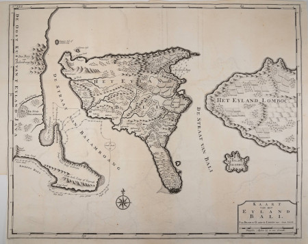
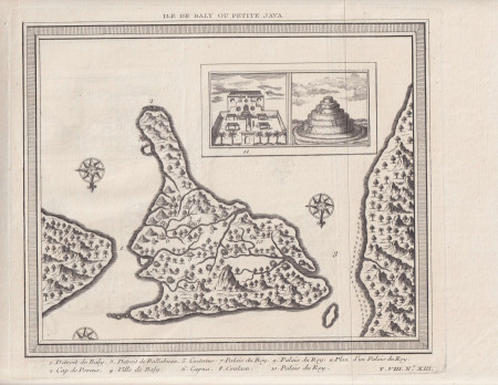
Bali Island - Large Map
Francois Valentyn
Antique Maps
/
Indonesia Maps
/
Bali & Lombok Maps
Year:
1724 - 26
Size:
450 by 560 mm.
Condition:
VG
SKU:
M.6000
Price:
USD 1,900
USD 1,900
Add to Basket
View Detail
Add to Favourites
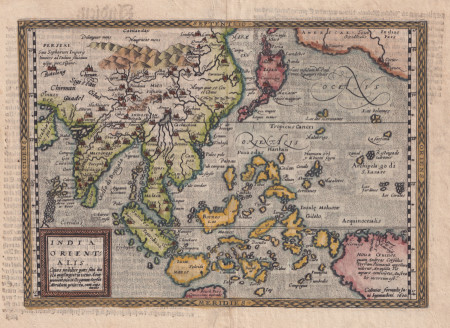
Map of Southeast Asia, Over 400 Years Old
Matthias Quad
Antique Maps
/
Asia Maps
/
South East Asia Maps
/
Indonesia Maps
/
China Maps
/
Australia Maps
/
Pre-1750 Maps
Year:
1600
Size:
228 by 305 mm.
Condition:
VG+
SKU:
M.0391
Price:
USD 2,200
USD 2,200
Add to Basket
View Detail
Add to Favourites
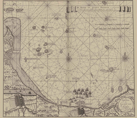
Batavia and Surroundings - Secret VOC atlas map
Van Keulen
Antique Maps
/
Indonesia Maps
/
Batavia & Jakarta Maps
/
Java Maps
Year:
ca. 1719
Size:
525 by 600 mm.
Condition:
G+ / Study images carefully
SKU:
M.1206
Price:
Price on Request
Price on Request
Request Price
View Detail
Add to Favourites
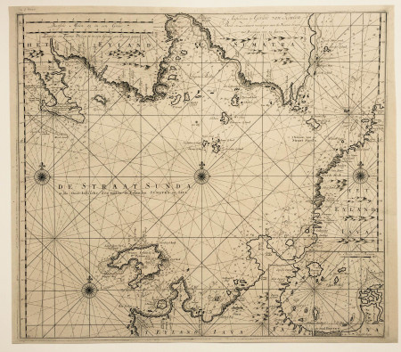
Sunda Strait - Secret VOC Atlas Map
Van Keulen
Antique Maps
/
Indonesia Maps
/
Java Maps
/
Sumatra Maps
/
Pre-1750 Maps
/
Sea Charts & Maritime Maps
Year:
ca. 1719
Size:
524 by 592 mm.
Condition:
VG+
SKU:
M.1204
Price:
USD 7,900
USD 7,900
Add to Basket
View Detail
Add to Favourites
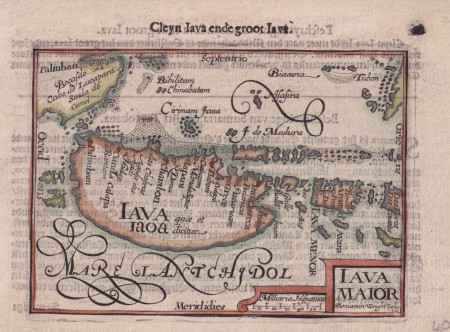
Java Island - ca.1606
Bertius
Antique Maps
/
Indonesia Maps
/
Java Maps
/
Pre-1750 Maps
Year:
ca. 1606
Size:
124 by 91 mm. ( engraving )
Condition:
VG+
SKU:
M.1202
Price:
USD 320
USD 320
Add to Basket
View Detail
Add to Favourites
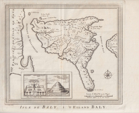
Bali, 1750
J. van Schley
Antique Maps
/
Indonesia Maps
/
Bali & Lombok Maps
Year:
null
Size:
342 x 251 mm
Condition:
G
SKU:
M.0195
Price:
USD 390
USD 390
Add to Basket
View Detail
Add to Favourites
Bali, 1753
J. van Schley
Antique Maps
/
Indonesia Maps
/
Bali & Lombok Maps
Year:
null
Size:
280 x 252
Condition:
G
Price:
USD 390
USD 390
Add to Basket
View Detail
Add to Favourites
East Asia Map, Dutch Golden Age Map
De Wit
Antique Maps
/
Asia Maps
/
South East Asia Maps
/
Indonesia Maps
/
Pre-1750 Maps
Year:
1680
Size:
46 by 56 cm.
Condition:
VG+
SKU:
M.0853
Price:
USD 2,800
USD 2,800
Add to Basket
View Detail
Add to Favourites
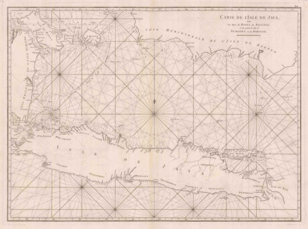
Sea Chart of Java, Borneo, Bali and Sumatra
Jean-Baptiste de Mannevillette
Antique Maps
/
Indonesia Maps
/
Java Maps
Year:
1775
Size:
750 x 530 mm.
Condition:
VG
SKU:
M.0077
Price:
USD 690
USD 690
Add to Basket
View Detail
Add to Favourites
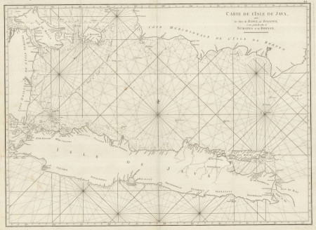
Sea Chart of Java Island
Jean-Baptiste d’Apres de Mannevillette
Antique Maps
/
Indonesia Maps
/
Java Maps
/
Sea Charts & Maritime Maps
Year:
1745
Size:
480 x 660 mm.
Condition:
VG
SKU:
M.0059
Price:
USD 1,750
USD 1,750
Add to Basket
View Detail
Add to Favourites
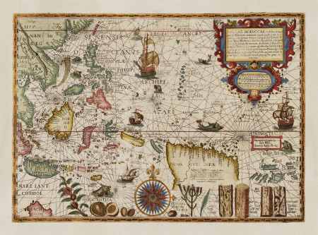
Antique Map of the Spice Islands, Moluccas ~ Year 1598
Petrus Plancius (1552 – 1622)
Antique Maps
/
South East Asia Maps
/
Indonesia Maps
/
Moluccas & Spice Islands Maps
/
Papua Maps
/
Special Collection
/
Pre-1750 Maps
/
Sea Charts & Maritime Maps
Year:
1598
Size:
380 x 540 mm.
Condition:
G+
SKU:
M.plancius
Price:
Price on Request
Price on Request
Request Price
View Detail
Add to Favourites
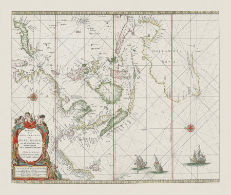
Sea Chart VOC Southeast Asia
Pieter Goos
South East Asia Maps
/
Indonesia Maps
/
Pre-1750 Maps
/
Sea Charts & Maritime Maps
Year:
ca. 1680
Size:
45 by 55 cm.
Condition:
G+
SKU:
M.0851
Price:
Price on Request
Price on Request
Request Price
View Detail
Add to Favourites
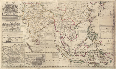
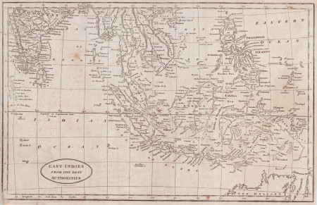
East Indies from the best authorities, antique maps of Southeast Asia
John Payne
Antique Maps
/
South East Asia Maps
/
Indonesia Maps
Year:
1798
Size:
31 by 20 cm.
Condition:
G
SKU:
M.0459
Sold
View Detail
Add to Favourites
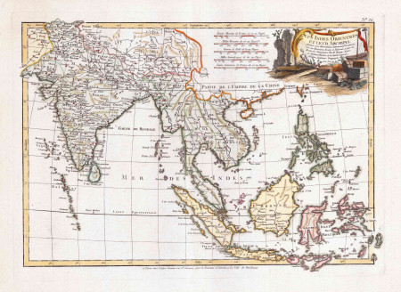
Southeast Asia, Old Decorative Map
John Senex
Antique Maps
/
South East Asia Maps
/
Indonesia Maps
/
India & Sri Lanka Maps
/
Pre-1750 Maps
Year:
ca.1700
Size:
38 by 26 cm
Condition:
G+ / Study images carefully
SKU:
M.0441
Sold
View Detail
Add to Favourites
Southeast Asia, Decorative Map
Rigobert Bonne
Antique Maps
/
South East Asia Maps
/
Indonesia Maps
/
India & Sri Lanka Maps
/
Korea Maps
Year:
ca.1770
Size:
50 by 35 cm.
Condition:
VG+
SKU:
M.0444
Sold
View Detail
Add to Favourites
Singapore and Western Indonesia Map
Antique Maps
/
Indonesia Maps
/
Singapore & Malaysia Maps
/
Java Maps
/
Sumatra Maps
/
Borneo & Kalimantan Maps
/
Pre-1750 Maps
Year:
ca.1740
Size:
40 by 30 cm.
Condition:
VG+
SKU:
M.0449
Sold
View Detail
Add to Favourites
Singapore and Indonesia Map
Isaak Tirion
Antique Maps
/
South East Asia Maps
/
Indonesia Maps
/
Singapore & Malaysia Maps
/
Java Maps
/
Sumatra Maps
/
Borneo & Kalimantan Maps
/
Pre-1750 Maps
Year:
ca.1740
Size:
40 by 30 cm.
Condition:
VG / Study images carefully.
SKU:
M.0450
Sold
View Detail
Add to Favourites
«
1
2
3
4
5
6
»